Taking precautions
Last Wednesday, they started to rebuild
the collapsed part of the roof of the Grolsch
Veste. This morning, the second truss was placed. This afternoon, I
noticed that they already had installed the horizontal braces, while
the crane was still holding the truss. It seems they are taking all
possible precautions to avoid a repeat of the disaster.
On Location
At 12:11, I bought the book On Location by Claudia Hellmann
and Claudine Weber-Hof, ISBN:9783765815850, for € 2,50 from
bookshop De Slegte.
Supernova
Yesterday evening, I made an attempt to see the supernova SN 2011fe, initially designated PTF11kly. It is still becoming brighter.
See some pictures.
I played with camera's and various lenses (belonging to my Zenit Camera), and even got my Philips webcam.
But I failed to find it, mainly due to light polution. The best I could do is this picture
shown on the right taken through the webcam of the star system Mizar in te Big Dipper.
Subtyping
Subtyping is a well-know techniques used in object-oriented modeling
with computer science. But in object-oriented programming, where the
focus is on behaviour, it often works counter intuitive. From a
mathematical point of view a circle is a subtype of ellipse, because
each circle is also an ellipse (albeit a special case), just like each
square is also a rectangle. But from a behavioural point of view an
ellipse is a subtype of a circle, because everything you can do with a
circle, you can also do with an ellipse, but with an ellipse you can do
some additional things, like change its angle. To represent an ellipse,
you need two extra parameters. For this reason, in a programming language
an ellipse is often modelled as a subtype of a circle. Sometimes, you
even see that people define a circle as a subtype of a point, because
a circle has a center-point. But for all circles, with radius larger than
zero, that point is not part of the circle itself.
In object-oriented modeling there is another important relationship
and that is composition, meanig to express that some object is part of
another object. In case an object always has another object as its part,
it is very tempting to define that object as a subtype of the part
object. In that case the composition relationship runs in the reverse
direction of the subtype relationship, which often leads to very strange
restrictions, while working with such objects. Subtyping is a powerful
mechanism, but in some case it is plainly wrong to use it.
GOGBOT Festival
At the end of the afternoon, I went to the old church
in the center of Enschede and looked at the GOGBOT Festival there. I found the Push-me! object the most interesting. I also walked
through the Physiognomic Scrutinizer and was identified as
Lily Allen.
I talked sometime with John Haltiwanger about the Ruby program he wrote.
Today, I took my I-gotU GPS
tracker with me. The @Trip PC program that comes with
it (to download the track) is not very good. So usually, I
just export it to GPX and use GPX Editor by Pixel K to clean-up the GPX track. In case
I visited some locations, I split the track into multiple tracks
and add some comment to each track. This is a lot of work and
it is not easy to establish when I started and ended my trip.
Next, I often import it in GoogleEarth
and save it as an KMZ file to be published on the web. KMZ files
can be viewed in Google Maps by putting the URL in the search string.
Now this morning, I got the idea to use waypoints to split the
track into separate tracks. This morning, I got the idea to
use the waypoint feature to split the track in smaller tracks.
You can create a waypoint by pushing the button on the tracker
shortly. This evening, I spend some time writing a small progam to process the GPX file produced by @Trip PC
and split the track on the waypoints. Waypoints look much like the
regular points in a track, so it was relatively easy to make the
tracks start and end with the waypoints. Now it is very easy, using
the GPX Editor, to remove the rubbish track that are occur when you go
inside a building for example, and to add comments to the 'real'
tracks.
Here is todays track as KMZ file
or in Google Maps.
(Improved program)
GOGBOT festival
Today, I went to the different GOGBOT
exhibitions again. I first went to the Tetem building. There I watched:
Next I went to 21rozendaal
and watch the exhibition of Yunchul Kim.
I was most impressed by his self portait: Handwritten jpeg data. Some ladies present told me he worked on it
for 3 months, six hours a day.
In Rijksmuseum Twenthe,
I watched the works of Ella Cassisi
(Facebook,
Blogspot). We shaked hands
before she walking me to her exhibition.
I walked through the dome on the Stationsplein where the dataphonics by
Ryoji Ikeda was played.
And finally, I went into the old church and played a little bit with
Push-me!. There seemed to be some network problems, because the two
boards where not connected.
KMZ file of my GPS track or
view in Google Maps.
Metamodel fascination
I often encounter a fascination with metamodeling within computer science and software engineering,
especially among those that have been brought up with the object-oriented paradigm.
What I mean that is seems that for some the metamodel is of a greater importance
than the model. Some even go as far as to state (explictly or implicitly) that
a model is part of a metamodel, instead of stating that a model has a metamodel.
(I think you also see this in for example the prominence of the subtyping in UML, or at least how it is used.) This often goes together with a stong emphasis
on the static typing versus the dynamic behaviour of a model. It is important to note
that there are basically two types of meta-models with respect to a model. This is
related to the fact that in many models it is possible to identify types or classes,
which makes it neccessary to define additional rules as how elements of the model
are restricted by these types and/or classes. These definitions are often refered
to as the metamodel. I would refer to this kind of metamodel as the typing metamodel.
But there is another metamodel, which describes how the primitive elements of the
model and the typing metamodel are related to each other. Because this kind of metamodel
says something about the model and the typing metamodel, it could be refered to as
being a meta-metamodel, but strangly enough that term is often used for denoting
the model of the typing metamodel itself. I would refer to this kind of metamodel
as the semantic (or structural) metamodel, as it described (often in words) how the
restrictions defined in the typing metamodel should be applied to the model. I think
one could state that a model belongs to a semantical metamodel, because the semantical
metamodel defines how the model should be interpreted, but that it is incorrect to
state that a model belongs to a typing metamodel. Another way to see this is to
make a difference between primitive types and user-defined types. The primitive types
are part of the semantic metamodel and the user-defined types are part of the typing
metamodel. I think that many problems around relating models with the same semantic
model but with different typing metamodels can be resolved by assuming these typing
metamodels (which define user-defined types) to be an integral part of the model.
Photosynth
This evening, I created my first Photosynth about some plants in a forest where I often walk with Li-Xia. I also took a picture of Li-Xia, which included the plants on the
side. On the right a part of that picture is shown with her portret. The plants
are outside this part. I also investigated some other methods for converting the
picture into a 3D model (also known as Structure from
Motion). I searched for Blender extentions, but could not find any suitable. At the end over the
evening, I found My 3D Scanner and gave
it a try. I also had a look at Clustering Views for Multi-view Stereo (CMVS), but it requires some more
study to be used.
Derived relations in ArchiMate
An interesting idea in the ArchiMate
modelling language is the concept of derived relations, which is described in more detail the journal paper Composition of Relations in Enterprise Architecture. The basic idea is
that the structural relations are transative and that the type of the derived relation
is the weakest type of the two structural relations that are combined, where the relation
types in decrease strength are: composition, aggregation, assignment, realisation,
used by, access, and association. ArchiMate also defines a number of view types, where
each view type restricts the types of objects that can be shown. ArchiMate only
defines a number of basic relations. It is possible that on a certain view type,
there is no basic relation defined between two types of object, but only a derived
relation. Using the derived relation, it is possible to determine the 'basic'
relation types for each view type. Some type of views are more generic than others,
a describe a different level of details. It is important to recognize that in an
architectural design one could work from the generic to the more specific, but also
from the specific to the generic. For example, one could start with deciding which
business processes make use of which application component, and at a later stage
define which application interface is used by which business process. But one could
also start with the detailed designed (possibly derived from another modeling domain)
and aggregrate a more generic view. It is even possible that different parts of the
organisation contribute different parts of the model. This leads to the idea that
a tool based on ArchiMate could be seen as a knowledge engineering tool, that collects
data from various sources, aggregates, and compares the data. A good knowledge engineering
tool also keeps track of the sources, and how these are combined, aggregated, annotated,
and modified by who and when.
At 15:09, My 3D Scanner started processing
the request I posted yesterday for combining the pictures into a single point cloud
and mesh. At 15:56, the job was completed. The point cloud consisted of 278639 points,
and I was rather astonished when I watched the point cloud on-line. I downloaded the
point cloud and also the mesh data. The mesh consist of 285196 points and 570252 faces.
I downloaded MeshLab to view the point cloud and mesh off-line. I know that MeshLab also has a filter for retrieving data
from Photosynth, but I could not find it, and so, I downloaded SynthExport. The Photosynth point cloud only consists of 7185 points. It is not
easy to combine the two point clouds, because they use a different coordinate sets.
I was a little surprised to see that estimated camera parameters that Photosynth
calculated are different for each picture. If Photosynth had recognized that all
the pictures where taken by the same camera, and that information was stored in
the images, it could have found a beter estimate using this knowledge. My 3D Scanner
does not give any information about the estimates it used for constructing the point
cloud and mesh data. For an even beter result, you could also calibrate you camera,
with for example Camera Calibration Tools by Dan Stoyanov (short instruction manual). But neither Photosynth and My 3D Scanner allow you
to enter such calibrations. It seems that both free Structure from motion on-line tools, have their limitations. So far, I haven't
found any good free structure from motion programs. There are several Matlab libraries
available, however Matlab itself is a commercial package (but with reduced prices
for academic use). What seems to be the most promising open source project is
libmv. But we will have to wait till version
2.0 before it supports structure from motion. In the evening, I installed Blender,
imported the mesh and played around a little with it. I watched some tutoral videos to
get to know Blender a little.
Sudokus
In one of our meeting rooms there has been a five by five grid on the board
with the words risk and impact besides it, where the squares where divided in four
connected groups. Some days ago, some one remarked that it looked like a Sudoku.
It did have two groups of five squares, but the remaining squares where divided
into two groups, which would have to ben three of course, making a total of five
groups with five squares. But it started me thinking about how may unique ways
there are two divide a five by five grid into five connected groups of five little
squares. I also wondered if their where divisions that would create impossible
Jigsaw Sudokus and/or how strong the restrictions are that are imposed by some division.
I thought a little about the three by three case and realized that there are only
two divisions, where one is the trivial case of three bars, posing no additional
restrictions. The other only has one unique solution once you fill in one row
or column in some manner.
Searching The On-Line Encyclopedia of Integer Sequences
on Sudoku, I found The number of ways to dissect
an N by N square into polyominoes of size N, which gives the number of non-unique
ways of dividing a sqaure grid into the given number of parts. When I looked at
some of the related sequences, I realized that restrictions on component size
(either in number of vertices and edges) is another property for which one can
proof that there exists a recurrence equation for graphs of the form GxPn
as I did with some properties in my research with respect to counting Hamiltonian paths. Later, when I studied the paper Counting Nonomino Tilings and Other Things of that Ilk by
Bob Harris, I discovered that that is
exactly what he did. I also thought about the restriction that if two neighbouring
edge belong to the same component that they should have an edge. Then I also got the
idea of Snake Sudokus, which are just like ordinary Sudokus with the additional
rule that the numbers should be placed as a snake in the available shape, meaning that
one should be able to walk from the lowest to the highest number. I also wondered if
there are division for which there is only two solution (with the order of the numbers
reversed). I also found the page: Math Games: Snakes on a Plane.
Books
This moring at 11:40, I bought the follwoing two books from bookshop De Slegte for € 2.50 each:
- De Archimedes Codex by Reveil Netz and William Noel
about the Archimedes Palimpsest.
ISBN:9789025363222.
- Harry Potter and the Order of the Phoenix
by J.K. Rowling. ISBN:9780747561071.
Taking some risks
The picture on the right shows the reconstruction of the roof of the Grolsch Veste at the end of the afternoon. The truss on the right was installed
today. The picture shows that the horizontal braces between this truss and the one on the
left of it, are installed as well and that the crane is not holding the truss. But it seems
that they still take some risks, because the design calls for cross bars between these two
trusses. I wonder if these will be installed next.
Cross bars
This morning around nine o'clock, they had already installed the highest cross bars on
the roof of the Grolsch Veste. When The picture I took at the end of the afternoon, shows that they installed some more
cross bars, but also that they were still installing some.
UARS
This morning it was said that the Upper Atmosphere Research Satellite (UARS) would fall back to the earth.
Around 11 in the morning, I retrieved the following table from
www.heavens-above.com for the coordinate 52.2076°N, 6.9214°E to
see when it would pass overhead:
| Date | Mag | Starts | Max. altitude | Ends |
| Time | Alt. | Az. | Time | Alt. | Az. | Time | Alt. | Az. |
| 23 Sep | 2.1 | 01:11:41 | 10 | NW | 01:12:54 | 16 | N | 01:14:07 | 10 | NE |
| 23 Sep | 0.4 | 04:13:56 | 10 | W | 04:15:22 | 21 | SW | 04:16:46 | 10 | SSE |
| 23 Sep | -0.3 | 23:03:50 | 10 | W | 23:05:14 | 41 | NNW | 23:06:36 | 10 | NE |
Then this afternoon, it was announced that it would fall back later then
said before, most likely early tomorrow. At 15:56 local time, I looked
at the table again, and found it had changed slightly. Probably because
the UARS is losing speed and getting behind. The table looked like:
| Date | Mag | Starts | altitude | Ends |
| Time | Alt. | Az. | Time | Alt. | Az. | Time | Alt. | Az. |
| 23 Sep | 2.1 | 01:11:49 | 10 | NW | 01:13:01 | 16 | N | 01:14:13 | 10 | NE |
| 23 Sep | 0.4 | 04:14:00 | 10 | W | 04:15:25 | 21 | SW | 04:16:48 | 10 | SSE |
| 23 Sep | 1.3 | 21:35:01 | 10 | SSE | 21:35:22 | 10 | SE | 21:35:42 | 10 | SE |
| 23 Sep | -0.3 | 23:04:16 | 10 | W | 23:05:43 | 42 | NNW | 23:07:11 | 10 | NE |
| 24 Sep | 1.2 | 02:06:04 | 10 | NW | 02:07:15 | 20 | NNE | 02:08:26 | 10 | ENE |
| 24 Sep | -0.5 | 03:36:19 | 10 | W | 03:37:32 | 25 | SW | 03:38:46 | 10 | SSE |
The greatest danger for an impact is still around the same time as before,
if you take the maximum altitude (in degrees from the horizon) as a marker
for the likelyhood of impact at your location.
Shortly after 11 o'clock this evening, Annabel
and I went outside to see if it would burn-up before our eyes, but we didn't
see anything.
Twitter UARS_Reentry
Today, the Upper Atmosphere Research Satellite (UARS) fell to earth. But up to today
it is unknown where. The only exact statement that has been made by NASA is that
it fell to earth between 3:23 and 5:09 UTC: Diagram of track. I found UARS_Reentry on Twitter to be the most informative. Spaceflight101 also
has an interesting page.
The table below is based on data from this source. It gives
an estimate of the location of the UARS based measurements made of the actual
position of the satelite combined with its known orbit parameters and its predicted
descending rate. The column "Age" gives information on how old the data is that
the estimation is based on. The age is given in day, which means that 0.01d equals
14 minutes and 24 seconds. I have underlined those values where there is a drop,
meaning that the estimate is based on new measurements. I also have added rows
for the earliest and latest time that NASA says that the satelite fell to earth.
     date-time         orbit perigee apogee  Position        Alt         Age       Reentry
       (UTC)          (mins)   (km)   (km)                  (km)
Fri 23 Sep 2011 21:15  87.56  149    154.5  51.1N, 68.4E  166.1km Unlit [0.14d]  -6.0h  3:15
Fri 23 Sep 2011 21:30  87.56  148.7  154.1   5.5N,114.8E  154.4km Lit   [0.15d]  -5.8h  3:18
Fri 23 Sep 2011 22:00  87.47  145.4  151.2  48.2S,116.0W  158.2km Lit   [0.05d]  -5.3h  3:24
Fri 23 Sep 2011 22:15  87.47  144.9  150.7   0.8S, 73.6W  145.1km Lit   [0.06d]  -5.0h  3:15
Fri 23 Sep 2011 22:30  87.46  144.5  150.3  47.0N, 32.5W  158.3km Unlit [0.07d]  -5.6h  4:06
Fri 23 Sep 2011 22:45  87.46  144    149.8  44.9N, 58.8E  159.8km Unlit [0.08d]  -5.3h  4:03
Fri 23 Sep 2011 23:00  87.45  143.5  149.3   3.6S, 97.9E  149.2km Lit   [0.09d]  -5.1h  4:06
Fri 23 Sep 2011 23:15  87.41  142.9  147.9  50.0S,142.7E  158.1km Lit   [0.04d]  -4.8h  4:03
Fri 23 Sep 2011 23:30  87.41  142.4  147.4  41.3S,127.1W  152.1km Lit   [0.05d]  -4.6h
Fri 23 Sep 2011 23:45  87.40  141.9  146.9   8.3N, 90.5W  142.8km Lit   [0.06d]  -4.3h
Sat 24 Sep 2011  0:00  87.40  141.4  146.4  52.7N, 41.0W  157.6km Unlit [0.07d]  -4.1h  4:06
Sat 24 Sep 2011  0:15  87.39  140.9  145.9  37.4N, 46.6E  153.6km Unlit [0.08d]  -3.8h
Sat 24 Sep 2011  0:30  87.39  140.4  145.4  12.8S, 81.1E  146.0km Lit   [0.09d]  -3.6h
Sat 24 Sep 2011  0:45  87.38  139.9  144.9  54.8S,136.1E  156.3km Lit   [0.10d]  -3.3h
Sat 24 Sep 2011  1:00  87.38  139.4  144.4  33.3S,140.3W  146.0km Lit   [0.11d]  -3.1h  4:06   Twitpic
Sat 24 Sep 2011  1:15  87.37  138.9  143.9  17.4N,107.0W  141.5km Lit   [0.12d]  -2.8h
Sat 24 Sep 2011  1:30  87.37  138.4  143.4  56.3N, 45.6W  156.3km Unlit [0.13d]  -2.6h
Sat 24 Sep 2011  1:40  87.36  138.1  143.0  44.0N, 15.9E  153.0km Unlit [0.14d]  -2.4h
Sat 24 Sep 2011  1:50  87.36  137.7  142.7  12.3N, 44.1E  143.7km Unlit [0.14d]  -2.2h  4:02
Sat 24 Sep 2011  2:00  87.20  131.3  137.5  22.4S, 65.3E  138.5km Lit   [0.03d]  -2.1h  4:06
Sat 24 Sep 2011  2:10  87.19  130.7  136.9  51.2S,101.2E  145.6km Lit   [0.04d]  -1.9h
Sat 24 Sep 2011  2:20  87.19  130.1  136.3  52.1S,168.0E  143.7km Lit   [0.04d]  -1.7h
Sat 24 Sep 2011  2:30  87.18  129.5  135.7  23.9S,154.7W  133.2km Lit   [0.05d]  -1.6h         Twitpic
Sat 24 Sep 2011  2:40  87.18  128.9  135.1  10.4N,133.6W  131.1km Lit   [0.06d]  -1.4h
Sat 24 Sep 2011  2:45  87.17  128.6  134.8  27.2N,122.1W  135.6km Lit   [0.06d]  -1.3h
Sat 24 Sep 2011  2:50  87.17  128.3  134.5  42.5N,106.3W  141.7km Unlit [0.06d]  -1.2h
Sat 24 Sep 2011  2:55  87.17  128.0  134.2  53.8N, 81.3W  146.6km Unlit [0.07d]  -1.1h+        Twitpic
Sat 24 Sep 2011  3:00  87.16  127.7  133.9  56.6N, 46.2W  148.1km Unlit [0.07d]  -1.1h+ 4:06
Sat 24 Sep 2011  3:05  87.16  127.4  133.6  49.0N, 15.3W  145.6km Unlit [0.07d]  -1.0h+
Sat 24 Sep 2011  3:10  87.11  128.4  133.1  35.3N,  4.5E  140.3km Unlit [0.02d]  -0.9h+
Sat 24 Sep 2011  3:15  87.11  128.1  132.8  19.1N, 17.7E  135.0km Unlit [0.02d]  -0.8h+ 4:03
Sat 24 Sep 2011  3:20  87.11  127.8  132.5   1.9N, 28.2E  132.1km Lit   [0.02d]  -0.7h+ 4:02
Sat 24 Seo 2011  3:23                                                                          earliest
Sat 24 Sep 2011  3:25  87.11  127.5  132.3  15.3S, 38.4E  132.6km Lit   [0.03d]  -0.6h+
Sat 24 Sep 2011  3:30  87.10  127.2  132.0  31.9S, 50.8E  136.0km Lit   [0.03d]  -0.6h+
Sat 24 Sep 2011  3:35  87.10  127.0  131.7  46.4S, 68.7E  140.1km Lit   [0.04d]  -0.5h+
Sat 24 Sep 2011  3:40  87.10  126.7  131.4  55.7S, 97.2E  142.4km Lit   [0.04d]  -0.4h+
Sat 24 Sep 2011  3:45  87.09  126.4  131.2  55.3S,132.9E  141.4km Lit   [0.04d]  -0.3h+
Sat 24 Sep 2011  3:50  87.09  126.1  130.9  45.4S,160.5E  137.1km Lit   [0.05d]  -0.2h+
Sat 24 Sep 2011  3:55  87.09  125.9  130.6  30.7S,177.8E  131.5km Lit   [0.05d]  -0.1h+
Sat 24 Sep 2011  4:00  87.09  125.6  130.3  14.0S,170.1W  127.1km Lit   [0.05d]  -0.1h+
Sat 24 Sep 2011  4:05  87.08  125.3  130.0   3.3N,159.9W  126.1km Lit   [0.06d]  -0.0h+
Sat 24 Sep 2011  4:10  87.08  125.0  129.8  20.4N,149.3W  129.1km Lit   [0.06d]  -0.1h+
Sat 24 Sep 2011  4:15  87.08  124.7  129.5  36.6N,135.7W  134.6km Unlit [0.06d]  -0.2h+
Sat 24 Sep 2011  4:20  87.08  124.5  129.2  50.0N,115.0W  140.1km Unlit [0.07d]  -0.8h
Sat 24 Sep 2011  4:25  87.07  124.2  128.9  56.8N, 83.2W  143.1km Unlit [0.07d]  -0.7h         image
Sat 24 Sep 2011  4:30  87.07  123.9  128.7  53.1N, 48.6W  142.0km Unlit [0.07d]  -0.7h
Sat 24 Sep 2011  4:35  87.07  123.6  128.4  41.3N, 24.5W  137.7km Unlit [0.08d]  -0.6h
Sat 24 Sep 2011  4:40  87.06  123.4  128.1  25.8N,  9.3W  132.2km Unlit [0.08d]  -0.5h?
Sat 24 Sep 2011  4:45  87.06  123.1  127.8   8.9N,  2.0E  128.0km Unlit [0.08d]  -0.4h?
Sat 24 Sep 2011  4:50  87.06  122.8  127.5   8.5S, 12.1E  127.2km Lit   [0.09d]  -0.3h?
Sat 24 Sep 2011  4:55  87.06  122.5  127.3  25.4S, 23.3E  129.6km Lit   [0.09d]  -0.2h?
Sat 24 Sep 2011  5:00  87.05  122.3  127.0  41.0S, 38.4E  133.7km Lit   [0.09d]  -0.2h?
Sat 24 Sep 2011  5:05  87.05  122.0  126.7  52.9S, 62.3E  137.1km Lit   [0.10d]  -0.1h?
Sat 24 Sep 2011  5:09                                                                          latest
Sat 24 Sep 2011  5:10  87.05  121.7  126.4  56.8S, 96.8E  137.4km Lit   [0.10d]  -0.0h?
Sat 24 Sep 2011  5:15  87.04  121.4  126.2  50.1S,128.9E  134.3km Lit   [0.10d]  -0.1h?
Sat 24 Sep 2011  5:20  87.04  121.1  125.9  36.8S,149.7E  128.9km Lit   [0.11d]  -0.2h?
Sat 24 Sep 2011  5:25  87.04  120.9  125.6  20.7S,163.4E  123.7km Lit   [0.11d]  -0.3h?
Sat 24 Sep 2011  5:30  87.04  120.6  125.3   3.5S,174.1E  121.2km Lit   [0.12d]  -0.3h?
Sat 24 Sep 2011  5:35  87.03  120.3  125.1  13.8N,175.7W  122.7km Lit   [0.12d]  -0.4h?
Sat 24 Sep 2011  5:40  87.03  120.0  124.8  30.5N,163.6W  127.5km Unlit [0.12d]  +0.5h??
Sat 24 Sep 2011  5:45  87.03  119.8  124.5  45.3N,146.4W  133.4km Unlit [0.13d]  +0.6h??
Sat 24 Sep 2011  5:50  87.03  119.5  124.2  55.3N,118.9W  ???     Unlit [0.13d]  +0.7h??
Split GPX with waypoints (part 2)
This evening, I improved the program to split GPX with waypoints, which
I wrote on the tenth. I sometimes forget to
push the putton to create a waypoint and I discovered that the GPX Editor
allows you to insert waypoints. I had to adapt the program to allow it
to process the output produced by GPX Editor. I already modified the
program to read from raw.gpx and write to split.gpx, such that I can execute
by means of a double click from the explorer.
Go Black
This afternoon, at 16:29, I bought the book Go Black by artist
Judith Vogt, ISBN:9789089100689
from bookshop De Slegte for € 2.50.
The book is about project where she paints her cloths black. I was attracted
to the book because of the index listing all the clothes that where
painted (including with page numbers where a picture of herself with
the piece occurs on) and because of a CD in the back of the book. At
home, the CD appeared empty. My DVD drive recognized it as an empty
recordable. It also looked like that on closer inspection. I emailed
the author and discovered that the CD should have been an DVD with
a short movie about the painting of the clothes that was made with a
Super 8 camera. I found that quite interesting, because I did not
know that Super 8 films can still be developed. She suggested that I
should ask the bookshop if they still have another copy. According to
the website of De Slegte they
still had some, but not in Enschede. I will make some inquiries.
This months interesting links
Home
| August 2011
| October 2011
| Random memories


 Friday, September 2, 2011
 Sunday, September 4, 2011
 Tuesday, September 13, 2011
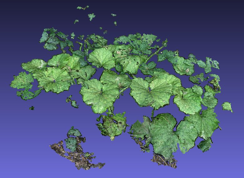 My 3D Scanner
 Monday, September 19, 2011
 Tuesday, September 20, 2011